


East Central Wisconsin PUMA, Wisconsin
About
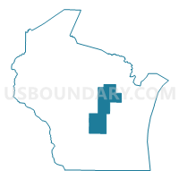
Outline

Summary
| Unique Area Identifier | 194407 |
| Name | East Central Wisconsin PUMA |
| State | Wisconsin |
| Area (square miles) | 3,521.64 |
| Land Area (square miles) | 3,429.57 |
| Water Area (square miles) | 92.07 |
| % of Land Area | 97.39 |
| % of Water Area | 2.61 |
| Latitude of the Internal Point | 44.38398050 |
| Longtitude of the Internal Point | -89.00412930 |
Maps

Graphs
Select a template below for downloading or customizing gragh for East Central Wisconsin PUMA, Wisconsin


Neighbors
Neighoring Public Use Microdata Area (by Name) Neighboring Public Use Microdata Area on the Map
- Central Sands--Wood, Portage, Juneau & Adams Counties PUMA, WI
- Dodge & Jefferson Counties PUMA, WI
- Fond du Lac & Calumet Counties PUMA, WI
- Marathon County PUMA, WI
- Marinette, Oconto, Door & Florence Counties PUMA, WI
- Oneida, Lincoln, Vilas, Langlade & Forest Counties PUMA, WI
- Outagamie County PUMA, WI
- Outer Green Bay City PUMA, WI
- Sauk & Columbia Counties PUMA, WI
- Winnebago County PUMA, WI
Top 10 Neighboring County (by Population) Neighboring County on the Map
- Brown County, WI (248,007)
- Outagamie County, WI (176,695)
- Winnebago County, WI (166,994)
- Marathon County, WI (134,063)
- Fond du Lac County, WI (101,633)
- Dodge County, WI (88,759)
- Portage County, WI (70,019)
- Columbia County, WI (56,833)
- Waupaca County, WI (52,410)
- Shawano County, WI (41,949)
Top 10 Neighboring County Subdivision (by Population) Neighboring County Subdivision on the Map
- Shawano city, Shawano County, WI (9,305)
- Waupaca city, Waupaca County, WI (6,069)
- New London city, Waupaca County, WI (5,685)
- Berlin city, Green Lake County, WI (5,435)
- Clintonville city, Waupaca County, WI (4,559)
- Menominee town, Menominee County, WI (4,232)
- Farmington town, Waupaca County, WI (3,974)
- Pulaski village, Brown County, WI (3,321)
- Wescott town, Shawano County, WI (3,183)
- Chase town, Oconto County, WI (3,005)
Top 10 Neighboring Place (by Population) Neighboring Place on the Map
- Shawano city, WI (9,305)
- New London city, WI (7,295)
- Waupaca city, WI (6,069)
- Berlin city, WI (5,524)
- Clintonville city, WI (4,559)
- Pulaski village, WI (3,539)
- Wautoma city, WI (2,218)
- Redgranite village, WI (2,149)
- Weyauwega city, WI (1,900)
- King CDP, WI (1,750)
Top 10 Neighboring Unified School District (by Population) Neighboring Unified School District on the Map
- Pulaski Community School District, WI (19,371)
- Hortonville School District, WI (18,952)
- Waupun School District, WI (18,859)
- Antigo School District, WI (17,774)
- Shawano School District, WI (17,348)
- Portage Community School District, WI (17,043)
- New London School District, WI (16,079)
- Waupaca School District, WI (15,851)
- Adams-Friendship Area School District, WI (14,638)
- Seymour Community School District, WI (12,917)
Top 10 Neighboring State Legislative District Lower Chamber (by Population) Neighboring State Legislative District Lower Chamber on the Map
- Assembly District 56, WI (67,841)
- Assembly District 47, WI (61,697)
- Assembly District 5, WI (61,133)
- Assembly District 86, WI (59,763)
- Assembly District 53, WI (59,677)
- Assembly District 89, WI (58,999)
- Assembly District 42, WI (57,978)
- Assembly District 71, WI (57,415)
- Assembly District 39, WI (56,515)
- Assembly District 6, WI (55,963)
Top 10 Neighboring State Legislative District Upper Chamber (by Population) Neighboring State Legislative District Upper Chamber on the Map
- State Senate District 16, WI (188,936)
- State Senate District 19, WI (175,997)
- State Senate District 13, WI (175,277)
- State Senate District 30, WI (173,432)
- State Senate District 2, WI (172,047)
- State Senate District 18, WI (170,917)
- State Senate District 14, WI (168,782)
- State Senate District 29, WI (167,310)
- State Senate District 24, WI (167,083)
- State Senate District 12, WI (157,332)
Top 10 Neighboring 111th Congressional District (by Population) Neighboring 111th Congressional District on the Map
- Congressional District 2, WI (751,169)
- Congressional District 8, WI (706,840)
- Congressional District 6, WI (705,102)
- Congressional District 7, WI (689,279)
Top 10 Neighboring Census Tract (by Population) Neighboring Census Tract on the Map
- Census Tract 1013, Oconto County, WI (8,785)
- Census Tract 127, Outagamie County, WI (6,282)
- Census Tract 1010, Waupaca County, WI (6,242)
- Census Tract 1009, Waupaca County, WI (6,103)
- Census Tract 16, Marathon County, WI (6,057)
- Census Tract 416, Fond du Lac County, WI (6,037)
- Census Tract 9612, Portage County, WI (6,036)
- Census Tract 216, Brown County, WI (5,929)
- Census Tract 9702, Columbia County, WI (5,868)
- Census Tract 131, Outagamie County, WI (5,814)
Top 10 Neighboring 5-Digit ZIP Code Tabulation Area (by Population) Neighboring 5-Digit ZIP Code Tabulation Area on the Map
- 54166, WI (17,002)
- 54981, WI (15,426)
- 53901, WI (14,445)
- 54961, WI (14,266)
- 53963, WI (13,910)
- 54409, WI (13,238)
- 54971, WI (10,827)
- 53965, WI (10,398)
- 54162, WI (9,065)
- 54929, WI (8,746)